


Rainfall model is a tools to predict/reconstruct the spatial and temporal evolution of rainfall.
Temporal and Spatial Characteristics and Variability of Rainfall
...rainfall is a random variable, but is not COMPLETELY RANDOM...
Understanding temporal and spatial characteristics of rainfall is central to water resources planning and management. Such information is important in agricultural planning, flood frequency analysis, flood hazard mapping, hydrological modelling, water resource assessments, climate change impacts and other environmental assessments.

Raindrop

What if a rainstorm dropped all of its water in a single giant drop?
What we know... a raindrop is simply some air moisture condensed ....
But.... How big can a raindrop be?
Diameter and Weight
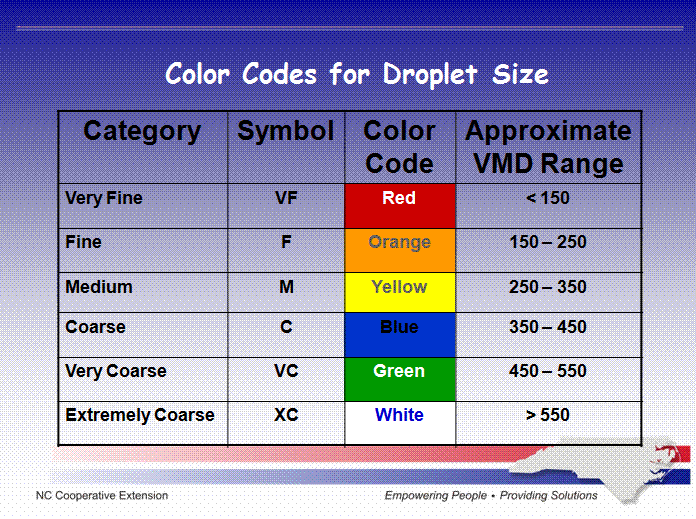
Droplet sizes are measured in microns.
A micron is 1/1000 millimeter, or about 1/25,000 of an inch.
A small
changes in droplet diameter make big differences in droplet weight.
An
increase in droplet diameter from 150 microns to about 190 microns
doubles the droplet weight.
An increase in droplet diameter from 150
microns to about 240 microns increases the weight 4 times. Doubling the
diameter to 300 microns increases its weight, and also its volume, by 8
times.
Heavier droplets fall more quickly and are less affected by air
movement.
Size and Number
When the
size of spray droplets is reduced, their numbers increase, and the
potential for drift also increases. Reducing droplet diameter in
half multiplies the number of droplets by eight.
Determination of Droplet Size and Number:-
The
Volume Median Diameter (VMD) refers to the midpoint droplet size
(mean), where half of the volume of spray is in droplets smaller, and
half of the volume is in droplets larger than the mean.
The cloud liquid water content (LWC):- expressed either in g/m3 or g/kg
Convective clouds have a higher LWC than stratiform clouds.
For convective clouds, the LWC increases with height (up to the level of glaciation)
and it is higher when the cloud base temperature is higher.
Maritime
clouds generally have fewer but larger drops than continental drops,
because there are fewer cloud condensation nuclei in the maritime troposphere
The LWC also depends on altitude in a cloud.
Five possible zones can be distinguished within a deep-convective cloud,
with glaciation in the topmost, an ice and droplet mixture in the next,
then a 'rainout' layer, below which was a zone of rapid droplet growth
by coalescence of droplets above 0°
C, and then at the base a zone of very slow growth by diffusion (4).
'Rainout' occurs in a zone where the effective radius is stable at about
20-25 micron, and droplet growth by coalescence is balanced by loss of
the larger droplets downwards.
The Qur'an, Knowledge, and Science

This is my main references:-
The Qur'an
contains several references to natural phenomena but these
references have clear purpose in explaining the deeper meaning to
life and existence in general.
The Qur'an leaves room for a
variety of interpretations but the consistency with recent
science within those acceptable interpretations is still
astounding.
Tirmidhi has narrated in the book of Jami'nya, Sa'id Al-Khudri Radliyallahu ' anhu, he said, that the Personalities of the Prophet ' Alahi wa Sallam has said:
"Allah Azza wa Glorified spoke
n, he kept himself busy by reading the Qur an and given my Affairs, then I will give him the virtue of people who ask (pray). And the virtue of Allah than the entire journey is like God's primacy over all his creatures. "
------------------------------
Narrated by Tirmidhi, number 2958 in chapter Fadha'ilul Qur an, Article number 25
The science of Al-Qur'an: the 20s
To the sides the miracle of Al-Qur an as in klarifikasikan by Al-Qurtubi, there were ten side kemukjizatanya:
1. the order of sentences is pretty amazing with different wording.
2. Uslubnya (redaksionalnya) a very beautiful, there is no other like it at uslub.
3. Grace is not possible by human beings.
4. the use of words in Arabic correctly and appropriately, that cannot be done by the Arab community.
5. the fulfillment of the promises are visible, for example, is the promise of victory of the believers, and other promises.
6. other Miracle is that Al-Qur an it tells things unseen is going to happen.
7. a wide range of science that it contains with which mankind can live in true.
8. this book also includes a wide variety of reasons.
9. There is no difference and contradiction between one meaning and another meaning contained in it.
10. his announcement about a variety of things that have happened since the beginning of the creation of the world until the time he (Al-Qur'an) down into this world.
Relationship between Condensation and Precipitation

As a basis, condensation is known as the physical process
by which a gas becomes a liquid which is the opposite of evaporation. When moisture cools
and reaches saturation point, the tiny particles of water condenses into larger
drops of water.
In scientific terms
condensation explained a chemical reaction in which water or another simple
substance is released by the combination of two or more molecules. The physical
process is represented by a liquid being removed from a vapor or vapor mixture.
Condensation can be form into:
Dew: Tiny drops of
water formed when condensation of water vapor occur at or near the surface of
the earth.
Frost: It is a frozen
condensation that occurs when air at ground level is super cooled below the
freezing point.
Fog: A mass of tiny drops of water that form when
water vapor condenses on a nuclei near the earth's surface.
Clouds: A cloud is a
mass of tiny drops of water that results from condensation which takes place
high up in the atmosphere.
Cooling Mechanisms
This is the basic
part of meteorology.
Frontal Mechanisms

A weather and precipitation formations largely depands with either warm or cold fronts. This will explains based on frontal mechanisms in which the global scale circulation drivesa humid warm front above a cold air mass.
Orographic Uplifts

Orographic
lifting occurs when an air mass is forced from a low elevation to a higher
elevation as it moves over rising terrain. As the air rises, it cools, often to
the point where condensation takes place, which can raise the relative humidity
to 100% and create clouds. As it descends down the other side of the mountain
range, it heats up and absorbs much of the moisture on that side of the range and
under the right conditions creating precipitation.
Thermal Convective Uplift

In thermal convective
uplift the humid warm air is raised at higher heights by the presence of
convective movements linked to temperature gradients and atmospheric
instability. Atmospheric stability was defined as the resistance of the
atmosphere to vertical motion.
Convergence Uplift

Convergent
uplift occurs when air enters a center of low pressure. As air converges into
the center of a cyclone it is forced to rise off the surface. As the air rises
it expands, cools, and water vapor condenses. Convergent and convective uplift
are the two most important uplift mechanisms for condensation in the tropics.
Under the intense sun, surface heating causes the moist tropical air to rise.
Convergence of the trade winds in the Intertropical convergence zone creates
copious rainfall in the wet tropics as well.
Subscribe to:
Posts (Atom)